Thursday, June 28, 2012
Rangeley, Maine - a Trail Town
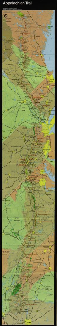
Rangeley is a real outdoors town. There is fishing, hiking, ATV riding and more. The Appalachian Trail passes nearby and the Northern Forest Canoe Trail goes through the heart of the town. Outfitters, guides, bookstores, equipment rentals, restaurants and even a photographer selling his work. Today many Appalachian Trail thru-hikers are here at the Town & Lake Motel. Northbounders who started in April or May are talking to Southbounders who started in June, exchanging information about "what's ahead". From the trail in 2009 while climbing over the Bigelow Range, took some pictures of the beautiful Flagstaff Lake. Soon I will be paddling there. It's a wonderful spot, the rain has stopped and nice weather is predicted for the next few days. Life is good.
A Kayaker's Body
Looking at a kayaker, it appears that the arms are used to propel the boat. That is only partly true. In fact the arms are too weak and the chance of damaging the shoulders is too high. As taught to me by Jim More, the proper Forward Stroke uses the entire body. It involves a twisting motion that uses muscles from the balls of the feet to the top of the neck. One very positive result is that during this trip my upper body, which shrunk during the Appalachian Trail thru-hike in 2009 has rebuilt. Another positive effect of kayaking is that there is no weight load on the body, especially the knees. Paddling upstream or against headwinds provides both strength and aerobic exercise. What's not to like?
Back to the Lakes... and the Rapid River Portage
From Errol, the paddle across Lake Umbagog went smoothly. Next, the Rapid River Portage. The Rapid River is a stunning whitewater run of Class III & IV rapids. Would love to come back and run them. The Portage was a different story. Start was hard to find. First long section was a trail strewn with boulders and rocks requiring some wheeling, pushing, shoving and conjoling through the mud and muck. Fortunately, that trail turned into a wheelable road. The next challenge was to find the correct road. Many roads are not shown on the map. Missed the correct one, signs are set up for people coming in the other direction. Ended up doing some extra miles on a muddy road and eventually finding a driveway to cut through to Lower Lake Richardson. Found the Narrows and contined on to Upper Richardson, camping at Whitney Point.
From there to Rangeley, Maine was a diverse paddle. Headwinds and waves on Upper Richardson. On Mooselookmeguntic Lake (just read it as a sentance to get the name right) the winds and currents had me fighting to go in a straight line. Skeg adjustments had little effect. Finally, on Rangeley Lake, a nice tailwind that rapidly pushed me into the town of Rangeley in a prompt and speedy manner.
From there to Rangeley, Maine was a diverse paddle. Headwinds and waves on Upper Richardson. On Mooselookmeguntic Lake (just read it as a sentance to get the name right) the winds and currents had me fighting to go in a straight line. Skeg adjustments had little effect. Finally, on Rangeley Lake, a nice tailwind that rapidly pushed me into the town of Rangeley in a prompt and speedy manner.
West Milan to Errol, New Hampshire
The portage from West Milan over to the Androscoggin was on road and provided some nice breaks. Camped at the picturesque Cedar Pond Campground (picture perfect pond with the White Mountains including Mt. Washington as a background) and continued the portage the following morning, in lots of rain. Another mid-portage stop was at the Great Northern Moose Lodge & Campground. Rick gave me a cup of coffee and we talked about the trail.
The Androscoggin River has some nice rapids and would be fun to run in the downstream direction. Going upstream involves several road portages to bypass these sections. Heavy rain all day, but the paddling environment was beautiful. Gives on the feeling of having really entered the Northeast Forest.
Wet, tired, and a bit chilled, finished the day in the micro town of Errol, NH. Population around 300. Two outfitters (one for supplies and one for trips), two convenience stores, a general store, and one motel. Doug at the Northern Waters Outfitters offered me a place to camp and a hot shower, but the attraction of total warmth and dryness won out. Owner Ricky checked me in to a room at the Errol Motel, offered to dry clothes, store the kayak, and whatever else would result in a nice stay. The local entrepreneurs have to think clearly and work hard to survive. It is always a pleasure to support these local businesses.
Stark and the Stark VIllage Inn
Had made a note to stop here, having heard it was a nice village and place to stay. Another rainy day made it even easier to have a night at the Inn. Stark was established in 1774, and the main buildings are kept in original condition and are still used... Church, School, Library and more. The Stark Village Inn has three rooms and is run by Nancy Spaulding and her boyfriend Michael. They were very informative and pleasant hosts.
 |
| Stark (from Wikipedia) |
Conneticut River and Groveton (Paper)
The Conneticut River provided a nice 20 mile stretch of easy paddling down a wide river. A welcome relief after the challenges of the Nulhegan. Met a few people out in canoes for a few hours or days.
At the town of Groveton, turned left to paddle the Upper Ammonoosuc River, upstream. Accurately described as a quickwater river, it made more use of the earlier gained skilled such as eddy hopping and tracking. Camped for the night in a mosquitoe filled campsite in Groveton.
Got up early the next morning and during the immediate portage around the paper mill's dam, decided to go into town for breakfast. There is one restaurant and one pizza place. The main street ends at the entrance to Groveton Paper and the office building at the gate says "We Are Here to Stay". The paper mill closed and the contract on the property states that the mill cannot be restarted by another company. Perhaps a kind of "non-compete clause". The evening before talked to a fisherman who drives 6 1/2 hours to work as a carpenter in New Jersey. Life is not easy in the local economy.
Three Bears and a Mouse
At the bottom of the Nulhegan River, set up camp in at lovely primative campsite. The NFCT has a logbook and registration box, so opened it up to see who had been there and what their comments were. The log book was a mess! The maker of the mess was sitting there in the plastic bag filled with chewed up paper nest looking just as comfortable as can be. So comfortable in fact, that he just stared at me not wanting to move!
Just preparing to cook dinner and heard an animal cry out. It was a bear cub. How cute... and where is the Mother?!?!

 |
| A mouse in a house... |
Just preparing to cook dinner and heard an animal cry out. It was a bear cub. How cute... and where is the Mother?!?!

Then there were THREE bear cubs, in the trees right next to the campsite! Made some noise to scare them away. Scared they were, but unlike an adult black bear (which would leave), they are told to climb a tree when there is trouble. My actions would have worked for an adult, but had the wrong effect with the cubs. Decided not to eat dinner or open food... left it sealed up in the kayak's storage compartment. Too tired to be concerned, so went to sleep.
Down the Nulhegan River
Yea, finally some downriver paddling! Near Island Pond, the small Nulhegan Pond forms the headwaters of the river.
Further downstream, the river changes to rapids which need to be portaged around, sometimes on trails so lightly used that they are impassable, sometimes the boat needs to be lined (held by rope from out of the boat and allowed to go down rapids where you do not feel comfortable being in the boat). Finally, the river becomes a "boulder field" where the rocks are too close together to be paddled through and need to be pulled around, through and over.
 |
| Upper section of the Nulhegan |
The river starts out very narrow and winding and during this long section there are many beaver dams, old and new. On the positive side, they hold back enough water to allow paddling. They also provide obstacles. The largest dam is about 4 feet above the water and the boat has to be dragged over. Many can be pushed over while still in the boat.
 |
| Crossing over a Beaver Dam |
 |
| Typical Beaver Dam looking upriver |
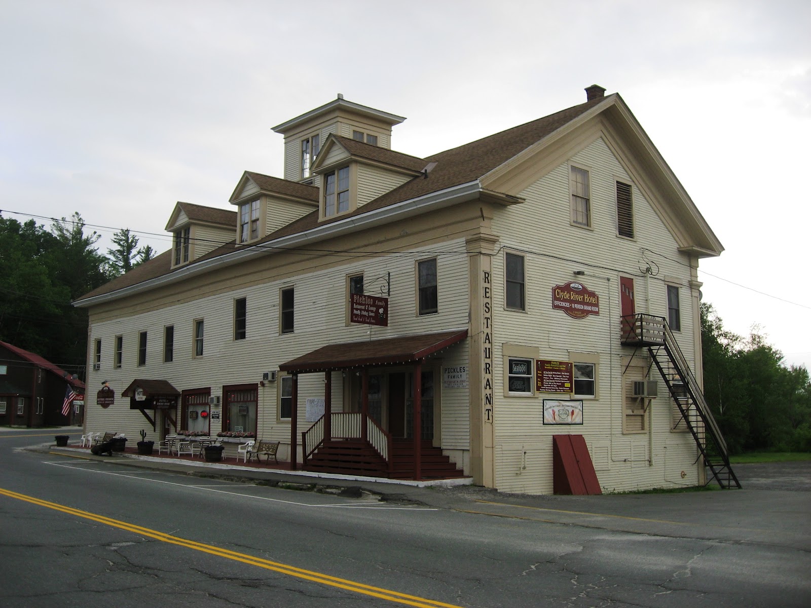
Logan was right. The Clyde River is not easy.
The voice of local knowledge told no lie. Going up the Clyde River is work and lots of it. The guidebook says "the 3-mile segment from Clyde Pond to Salem Lake may be the most difficult upstream paddling of the NFCT".
The reward toward the end (headwater) of the Clyde River is traveling through the "fen" from Ten Mile Square Road to Five Mile Square Road. A fen is an uncommon form of wetland where the water broadens over a large area and finding the way through is like a giant puzzle. It is packed with wildlife. My favorite part of the trip so far. Giant Bald Eagle nests are right next to the water. They are Big birds!
A more detailed description of a fen is at http://en.wikipedia.org/wiki/Fen
That evening, I arrive at Island Pond and the headwaters of the Clyde. The river goes directly underneath the formerly infamous and now quiet Clyde Hotel. Tired after several hard days, it is time for a "zero" or day off to let the body rebuild. The small town of Island Pond is very hospitable and provides a nice break from the trail.
The reward toward the end (headwater) of the Clyde River is traveling through the "fen" from Ten Mile Square Road to Five Mile Square Road. A fen is an uncommon form of wetland where the water broadens over a large area and finding the way through is like a giant puzzle. It is packed with wildlife. My favorite part of the trip so far. Giant Bald Eagle nests are right next to the water. They are Big birds!
A more detailed description of a fen is at http://en.wikipedia.org/wiki/Fen
 |
| Paddling under the Clyde Hotel is part of the Trail |
 |
| The Clyde Hotel |
That evening, I arrive at Island Pond and the headwaters of the Clyde. The river goes directly underneath the formerly infamous and now quiet Clyde Hotel. Tired after several hard days, it is time for a "zero" or day off to let the body rebuild. The small town of Island Pond is very hospitable and provides a nice break from the trail.
 |
| Lovely Island Pond |
Back in the USA - Border Patrol and Immigration
The US Canadian border runs across Lake Memphremagog 6 1/2 miles south of Perkins Landing. No need to stop at Canadian Customs and the US Immigration is a video phone at the dock in Newport, Vermont. Just south of the border, two large jet skis pulled up driven by fully uniformed (handcuffs, guns, etc) Border Patrol guards. They said "we don't see too many kayaks coming down the lake so we thought we would see what you are up do". After answering the standard questions we talked about the trail and my trip. They had not heard about the earlier history of the lake and border control. During Prohibition, the Canadians would fill a large island cave just to the north with liquor and during the night Al Capone's workers would pick it up by boat in the summer and automobile in the winter. The job of border patrol would have paid well in those days as Al had just about everyone in his pocket. Today, the guards will have to settle for getting a sun tan and driving jet skis for a living.
That evening, arrived in Newport, Vermont. Did the video phone check-in with US Immigration. "What is the name of your boat?" "The name of my boat? It is a kayak." "Some people name their boats", he says. Of course, but not me. What to fill in the name of boat space? "OK, give me the type of boat, manufacturer and the model." Then we were done.
Paddled across the bay and got a space in the township campground. Walked into town. Logan says to me after hearing about the trail "Nobody paddles UP the Clyde River!". For me, that is tomorrows journey.
That evening, arrived in Newport, Vermont. Did the video phone check-in with US Immigration. "What is the name of your boat?" "The name of my boat? It is a kayak." "Some people name their boats", he says. Of course, but not me. What to fill in the name of boat space? "OK, give me the type of boat, manufacturer and the model." Then we were done.
 |
| Arrival in Newport, Vermont |
Perkin's Landing on Lake Memphremagog
 |
| Calm Lake Memphremagog |
 |
| This duck wouldn't stay away if I was eating or cooking. |
The Grand Portage to Lake Memphremagog.
The question in traveling by water from west to east in Vermont is how to cross the Green Mountains. The trail founders decided to cross between the watersheds far to the north, and that is why the Northern Forest Canoe Trail goes into Canada. The crossing is still a portage, but need not climb to the heights of the Green Mountains to the south. Officially the longest portage on the trail, it is called The Grand Portage. It starts just north of Masonville, continues along Chemin Peabody, and ends at Perkin's Landing. Total distance is 5.7 miles. People living along the way are friendly, ask if you would like a ride, need water or anything else. Although long, the road is easy to wheel and getting over the hills just takes determination as compared to the skill required of other portages.
Almost to the end when the Jewetts General Store comes into view. Time to have a snack and talk with the owners. Three sisters have kept running the store as second generation owners and it has a constant stream of customers. Boat dock down one road, ski area down the other.
Reached the lake, Perkins Landing and called it a day. The small park is open to thru-paddlers for overnight camping. Boat dock beside, small beach, good views. Nice place to camp for the night.
 |
| Looking back to the start of the Grand Portage |
 |
| Just past the start. Survival, just what I was thinking about! |
 |
| Close to the end... the wheels are still on and working. |
 |
| Jewetts General Store |
Canada: Friendly people and small enterprises
The main language of this part of Canada is French. After a mere Bonjour, it is time for me to switch to English. It is the effort that counts in any language, and no different here. The Canadians prove to be a friendly group.
Paddling along the Missiquoi, I come across a sign by the river "Canoe & Co.". The owner, Francois, has a business renting canoes and kayaks for people to take on the river (unlike my trip, in a downstream direction!) and has been running it for 12 years. We have a nice chat and he invites me to camp for the night.

The next day in Masonville I ask locals at the town square about a good place to eat. They recommend The Owl's Bread Boulangerie. What a recommendation it is! The Tuna Nicoise Sandwich with Salad is my most gourmet meal on the trail so far. On the way out of town, Francois drives past and says hello, and his girlfriend comes out of her work place to offer me directions.
Paddling along the Missiquoi, I come across a sign by the river "Canoe & Co.". The owner, Francois, has a business renting canoes and kayaks for people to take on the river (unlike my trip, in a downstream direction!) and has been running it for 12 years. We have a nice chat and he invites me to camp for the night.

During the winter, Francouis works in the ski industry around the mountains in the background of this photo. What a weather dependant life! Water levels in the summer and snow quantities in the winter determine his total income and business results. Is that more out-of-ones-control risk than a farmer takes?
 |
| Local Ski Area viewed from Canoe & Co. |
 |
| Thanks "Owl" for a tasty lunch |
Crossing into Canada

Up the upper Missiquoi, new skills required
Unlike the previously slow moving section, further upriver the Missiquoi drops more quickly which means more challenging travel in my upstream direction. Strength, form and coordination in paddling become essential.
Improved reading of the water and river conditions results in more efficient use of energy and power. Why paddle in a fast moving section when a slower moving part of the river is available? Depth of water is a consideration since getting a full blade in the water is more efficient. If there are obstacles in the water, typically rocks, there is sometimes an eddy area below and often it is possible to "eddy hop", going from below one rock to below another upstream, saving lots of time and energy.
Often unavoidable, there are many situations where getting in and out of the boat is required. Considering the current, gravel bars, sand bars, slippery rocks and sometimes manmade obstacles like metal bars beneath the water, this is a challenging, time consuming and tiring exercise. Tracking the boat (pulling it upstream with a rope tied to the bow) is often the only way to continue onward.
My skills have developed quickly in this demanding environment.
Wednesday, June 13, 2012
Day Off in Enosburg Falls, VT
13 June 2012
211 miles of 710 trail miles have been completed in 12 days. My body tells me it is time for a break. 8-10 hours of paddling each day with varied conditions and new challenges have pushed by body, not to its limits by any means, but enough that the newly building muscles need a day off. Yesterday, found the quaint Somerset Inn and rented a room from Ms. Avis. Since then have been working on housekeeping tasks, photos, and this blog. Oh yes, and eating.
Tomorrow will get back on the Missisquoi and head northeast into Canada. My bounce box with computer will be sent to Rangeley, Maine which is both a NFCT Trail Town and an Appalachian Trail Town. Looking forward to posting some more stories and photos from there. That's 426 miles into the NFCT.
Hope you enjoy the stories.
Mark Fromm
Who is Thru Paddling now?
According to the registers along the trail (first one in Old Forge, PA), there are three boats ahead of me attempting a thru-paddle.
1. Joe Peterlin in a kayak he built. He also thru-hiked the Appalachian Trail NOBO (north bound) in 2008.
2. A lady from Pennsylvania who built a beautiful canvas and wood canoe in Maine.
3. Team E3, two ladies and a man (their given names all start with "E") in one canoe who according to Dave Cilley plan to complete the trail in 28 days (perhaps a record for a three person team?).
Checking Joe's website and Blog, it seems that problems with his wheels have taken him off the trail. My comment posted on his blog "So far (200+ miles into the thru paddle), my Sea to Summit "Small Cart" has worked out. It is the weak link in my gear, but nobody has a perfect solution. I think that a muscular design that can withstand max abuse is best, even if other features are not optimal. Some portages beyond where you stopped are much more stressful on the gear (and paddler!). Wish you success on your next attempt."
On April 30, 2012 the following was posted on the NCFT Facebook page "Michiganers Brian Wolf & Mike Messink began an NFCT thru paddle last week. The wintry weather is keeping them challenged!" http://adirondackdailyenterprise.com/page/content.detail/id/530542/Long-journey-gets-off-to-cold-start.html?nav=5008 Status unknown.
The status of the others is not known.
There is no easy way to find out who is behind me.
Devyn's hospitality. Locals at Breakfast.
11 June 2012
After a tougher than planned day, decided to stop for some water at Devyn’s Deli & Creemee Stand in Sheldon, VT. Hard to see from the water, the workers at the Hydro station had mentioned where to find it. Owner Amy was working there, and mentioned that another thru-paddler had stayed there and invited me to do the same. Turns out it was Cathy Mumford. Ordered a grinder (Sub Sandwich) and a Creemee (Ice Cream), and decided to stay and camp in their back yard by the river. Took a walk down the nearby Rail Trail and watched some Little League baseball. Starting to feel tired these days, time for a break to let the body rebuild.
Early the following morning, went in when Devyn's opened at 6:30, ate breakfast and talked with the local crowd. It is a nice way to share some stories, meet some people and to better understand the local scene.
Up the Missisquoi River
The Missisquoi River is different from anything encountered yet. It is slow moving, dark brown, and very muddy. Due to the slow moving water, earlier travelers selected this route for commerce and travel. The river mouth is a wildlife preserve and for several miles, the river banks are packed with wildlife, especially birds.
There are many dams on the river, and now the portages are more "up" than "down" due to travelling upstream. Dam to calm water to rapids to portage at dam is the new routine. At the Sheldon Springs Hydro Co. facility, there is a particularly long and hot portage. Two of the workers there offered to help out with a ride, water and information. Very nice. Being somewhat of a "traditionalist" wanting to move under my own power, I walk.
Agribusiness surrounds the river. The farms are combining and getting larger. Equipment used for farming is also increasing in size. Dairy farms are the main business, with milk being shipped daily to the Boston market.
Crossing Lake Champlain
09 & 10 June 2012
Crossing Lake Champlain can be difficult, Dave Cilley and others tell me. The waves are commonly 3-4 feet high and can be swells or white caps. A boat much longer than 10 feet is optimal they say. It is likely that there will be a need to stage carefully for the crossing (west to east and north to south, about 25.5 trail miles in total). People talk about crossing at 3am, before winds pick up.
Upon arrival at the boat ramp near the mouth of the Saranac River, Carla gives me her Marine Band Radio and has me listen to the weather forecast. She is there to advise boaters about invasives and check that their boats are properly cleaned. The weather forecast is for unusually calm conditions on the lake. Rather than waiting, I decide to double up on the day's planned mileage and continue onward. Waves are about one foot high and the famed high wind from the south can hardly be felt. Only complaint, I have dressed for potentially severe conditions and am overheating in the warm sunny weather. Nobody around Lake Champlain complains about that!
The afternoon's paddle takes me from New York to Vermont, across to Hero Island and into "the Gut", a pond of water in the middle of the lake which is sheltered from the weather. That's enough for one day for me. The map mentions that thru-paddlers may be able to camp at Campmeeting Point in the Knight Point State Park in cases of emergency. Ranger Mike is just leaving for the day and we talk for awhile. Although it is not a emergency, being really tired from the extra distance covered results in my preference for not wanting to cross another four miles over open water to an official campsite. The Ranger agrees and gives me permission to stay. It is a nice spot, sometimes used for weddings.
Crossing Day Two. Up early and on the water, this time headed north. Breakfast stop at the North Hero General Store. This store has a nice selection of just about everything. The proprietors have a good sense of humor. Notice the red and blue bench seats in front? They are labeled "Republican" and "Democrat" (there are other seats nearby).
After a lunch stop on the northern tip of Hero Island, the final trip north almost to the Canadian border in dead calm water on a hot sunny day. The crossing has been accomplished. I enter the West Branch of the Missiquoi River. Time to start paddling 200 miles upriver.
Crossing Lake Champlain can be difficult, Dave Cilley and others tell me. The waves are commonly 3-4 feet high and can be swells or white caps. A boat much longer than 10 feet is optimal they say. It is likely that there will be a need to stage carefully for the crossing (west to east and north to south, about 25.5 trail miles in total). People talk about crossing at 3am, before winds pick up.
Upon arrival at the boat ramp near the mouth of the Saranac River, Carla gives me her Marine Band Radio and has me listen to the weather forecast. She is there to advise boaters about invasives and check that their boats are properly cleaned. The weather forecast is for unusually calm conditions on the lake. Rather than waiting, I decide to double up on the day's planned mileage and continue onward. Waves are about one foot high and the famed high wind from the south can hardly be felt. Only complaint, I have dressed for potentially severe conditions and am overheating in the warm sunny weather. Nobody around Lake Champlain complains about that!
The afternoon's paddle takes me from New York to Vermont, across to Hero Island and into "the Gut", a pond of water in the middle of the lake which is sheltered from the weather. That's enough for one day for me. The map mentions that thru-paddlers may be able to camp at Campmeeting Point in the Knight Point State Park in cases of emergency. Ranger Mike is just leaving for the day and we talk for awhile. Although it is not a emergency, being really tired from the extra distance covered results in my preference for not wanting to cross another four miles over open water to an official campsite. The Ranger agrees and gives me permission to stay. It is a nice spot, sometimes used for weddings.
 |
| View from Campmeeting Point into The Gut |
Crossing Day Two. Up early and on the water, this time headed north. Breakfast stop at the North Hero General Store. This store has a nice selection of just about everything. The proprietors have a good sense of humor. Notice the red and blue bench seats in front? They are labeled "Republican" and "Democrat" (there are other seats nearby).
 |
| North Hero General Store |
After a lunch stop on the northern tip of Hero Island, the final trip north almost to the Canadian border in dead calm water on a hot sunny day. The crossing has been accomplished. I enter the West Branch of the Missiquoi River. Time to start paddling 200 miles upriver.
Saranac River and the False Portage
Largest and Longest elevation drop on the trail is down the Saranac River. About 1,300 feet over 41.5 miles. There are several dams along the way. The river can be low at points with a need to get out of the boat and pull it through. Fortunately for me, there is some rain along the way and the hydro stations release enough water that it is not necessary to get out of the boat. Sometimes however it gets shallow and taking weight off the seat and transferring it to the seatback and foot pegs is what allows the boat to get through shallow spots.
At the end of the Saranac River, it passes through the city of Plattsburgh, NY. The city was the site of a famous naval Battle of Plattsburgh between US (3,400 men) and British (10,000 men) warships during the War of 1812. http://en.wikipedia.org/wiki/Battle_of_plattsburgh The US won. The river through Plattsburgh is continuous Class I & II rapids. Fun. Coming around one bend, there is a coffer dam and large signs advising that a portage is required. Time to haul the gear up a long steep flight of stairs (with ropes, again) and start walking. Soon, the obvious portage route vanishes. A police station is there, and they advise me to "put in anywhere". There is no work being done on the river, and no clear reason for the forced portage. In goes the boat, right behind the police station, just below where it was taken out!
At the end of the Saranac River, it passes through the city of Plattsburgh, NY. The city was the site of a famous naval Battle of Plattsburgh between US (3,400 men) and British (10,000 men) warships during the War of 1812. http://en.wikipedia.org/wiki/Battle_of_plattsburgh The US won. The river through Plattsburgh is continuous Class I & II rapids. Fun. Coming around one bend, there is a coffer dam and large signs advising that a portage is required. Time to haul the gear up a long steep flight of stairs (with ropes, again) and start walking. Soon, the obvious portage route vanishes. A police station is there, and they advise me to "put in anywhere". There is no work being done on the river, and no clear reason for the forced portage. In goes the boat, right behind the police station, just below where it was taken out!
Dammed Rivers
09 June 2012
Rivers are starting to have a number of dams built at regular intervals. Paddling downstream, most have buoy's in front and large warning signs. But not all. The Indian Rapids Dam is especially dangerous. It is an old dam that from upriver appears breached. There are no warnings.

Getting past this old dam entails getting the boat and gear up an almost vertical "path". It took two ropes, one to hold the boat from slipping backwards and the other to use in a pulley system and divide the gear weight (about 100 pounds) in half.

Canoe Carry (Portage)
Getting from one piece of water to another, boat and all gear, requires what in the Adirondacks is called using a "Canoe Carry". Otherwise known as a Portage. Best estimate of my portage weight is 40 pounds for the boat and 60 for gear, water, fuel and food. If it can all be moved while packed up, that is the portage distance x 1. If a second trip is needed, then x 3. If a third trip is needed, x 5. Moving everything will a single trip is therefore a top priority. Some portages are easy. Wheels can be used. Not much effort is required.
Some portages are rough and require unpacking the boat. Here is the Raquette Falls Carry. Very steep to start and not wheelable. It took me 3 trips to move everything over the 0.6 mile carry (0.6 x 5 = 3 miles).
 |
| An Easy Portage |
Some portages are rough and require unpacking the boat. Here is the Raquette Falls Carry. Very steep to start and not wheelable. It took me 3 trips to move everything over the 0.6 mile carry (0.6 x 5 = 3 miles).
 |
| Warning sign for Raquette Falls. Note the broken canoe piece on the sign. |
 |
| Steep uphill start of Raquette Carry
|
30 miles to a non-existant town
07 June 2012
In perhaps a subconscious attempt to compensate for a day off, or more likely just feeling good after a day of rest and good food (fuel) intake, got started early and kept going almost until dark. The weather was calm, and the day sunny. So just kept going beyond the originally planned camping spot. Ended up at the top of the Class V Teft Pond Falls. With another Class III rapid just below, decided to pull out for a 3+ mile wheeled portage to Clayburg. On the map, the road intersection at Clayburg is marked as a "hamlet". In fact, it is only a road intersection. Tired and with darkness falling, decided to seek permission to camp by the river on private property. Walking up to the first house and knocking on the door, noticed a History Channel whitewater boating show on the TV. A good sign. Mark answered, and said no problem to set up camp. He also offered to take me to the store. Due to being quite tired, just set up camp, cooked dinner and went to sleep.
In perhaps a subconscious attempt to compensate for a day off, or more likely just feeling good after a day of rest and good food (fuel) intake, got started early and kept going almost until dark. The weather was calm, and the day sunny. So just kept going beyond the originally planned camping spot. Ended up at the top of the Class V Teft Pond Falls. With another Class III rapid just below, decided to pull out for a 3+ mile wheeled portage to Clayburg. On the map, the road intersection at Clayburg is marked as a "hamlet". In fact, it is only a road intersection. Tired and with darkness falling, decided to seek permission to camp by the river on private property. Walking up to the first house and knocking on the door, noticed a History Channel whitewater boating show on the TV. A good sign. Mark answered, and said no problem to set up camp. He also offered to take me to the store. Due to being quite tired, just set up camp, cooked dinner and went to sleep.
Saranac Lake Village
06 June 2012
Took a zero day (no paddling) to let the body rebuild and take care of some business. Found the pleasant Adirondack Motel lakeside, and settled in. Visited the St. Regis Canoe Outfitters and got some excellent advice and updates from owner and local author (Adirondack Paddler's Guide: Finding Your Way by Canoe and
Kayak in the Adirondack Park) Dave Cilley. It was a nice break. First two maps (of 13) have been completed.

 |
| View from the Adirondack Motel |

The NFCT continues through the center of the old town...
Wildlife

Middle Saranac Lake & Island Hopping
04 June 2012
There are three Saranac Lakes, Upper, Middle and Lower. Despite the numerous vacation homes in the area, there are not many on the Middle Saranac Lake. The reason may be the weather. Wind funnels down a valley and for my crossing created two foot white capped waves either head on or 45 degrees to the left. Paddling conditions were challenging. Fortunately, the boat, equipment and clothing were all up to the conditions. To get across the lake required "ferrying" (paddling into the wind and waves at a 45 degree angle, the result being a sideways motion in the desired direction). At one point, a duck popped up in the stormy waves, looked at me, then disappeared. Waves continuously crashed over the bow and it was raining steadily. There were some islands which provided shelter and a chance to rest on the leeward side. Trial by storm.
There are three Saranac Lakes, Upper, Middle and Lower. Despite the numerous vacation homes in the area, there are not many on the Middle Saranac Lake. The reason may be the weather. Wind funnels down a valley and for my crossing created two foot white capped waves either head on or 45 degrees to the left. Paddling conditions were challenging. Fortunately, the boat, equipment and clothing were all up to the conditions. To get across the lake required "ferrying" (paddling into the wind and waves at a 45 degree angle, the result being a sideways motion in the desired direction). At one point, a duck popped up in the stormy waves, looked at me, then disappeared. Waves continuously crashed over the bow and it was raining steadily. There were some islands which provided shelter and a chance to rest on the leeward side. Trial by storm.
Day One
01 June 2012, Old Forge, NY
This morning it was time to get started on the trip. Pat took some photos, packed up the boat, and we bid farewell.
First on the trail is the Fulton Chain of lakes. Started at Lake 1 and finished at Lake 7. Had originally planned a 10 mile day, but already the urge to keep traveling was there and it ended up being 14 miles. The Portages between lakes were mostly flat and on some kind of road. Easy. The lakes are packed with vacation homes, docks and boats. Last weekend was Memorial Day a busy holiday, but now it is hard to see anybody around. Paddling was peaceful, until the end of the day. Upon entering Lake 7, there was a headwind and waves with whitecaps. Tired and inexperienced, it took some extra effort to reach the campsite. Looking back the next day in calm weather, one could wonder what the challenge was.
This morning it was time to get started on the trip. Pat took some photos, packed up the boat, and we bid farewell.
 |
| Western Terminus of the NFCT |
 |
| First Stroke of the trip... |
First on the trail is the Fulton Chain of lakes. Started at Lake 1 and finished at Lake 7. Had originally planned a 10 mile day, but already the urge to keep traveling was there and it ended up being 14 miles. The Portages between lakes were mostly flat and on some kind of road. Easy. The lakes are packed with vacation homes, docks and boats. Last weekend was Memorial Day a busy holiday, but now it is hard to see anybody around. Paddling was peaceful, until the end of the day. Upon entering Lake 7, there was a headwind and waves with whitecaps. Tired and inexperienced, it took some extra effort to reach the campsite. Looking back the next day in calm weather, one could wonder what the challenge was.
 |
| Part of the Fulton Lake Chain |
Subscribe to:
Posts (Atom)